Research/Academic Showcase
Texas Tech University
Howard Hughes Medical Institute Gives $1.5 Million to Texas Tech's Science Education Program
Texas Tech University Health Sciences Center
U.S. Congressman Visits Health Sciences Center's Department of Speech, Language and Hearing Sciences
Alumni Highlights
Llano Wines and Texas Tech: a Tasty Combination
Catching Up With Your Fellow Red Raiders
Development
Endowed Chair Created in Wildlife Management
Athletics
Floren Named to PING All-America First Team
Pair of Red Raiders Named to Preseason Lists
Texas Tech University Press
New Book Lists Collections of Vintage Clothing
Helpful Links

Preserving Liberty – Part 2
Historic Preservation Team Returns to New York, Continues Mapping an American Icon.
Research/Academic Showcase
Quick, close your eyes.
Now try to visualize the Statue of Liberty.
Piece of cake, huh?
Most people can conjure a mental image of this icon without much effort – the green tint of her skin, her billowing gown, the bold thrust of her torch; features known the world over.
Yet, while her famous visage has been captured by more snapshots than any red carpet regular, Lady Liberty lacks the one likeness that the National Park Service craves most: a set of measured drawings depicting her exterior.
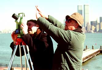 John Burns works with a photographer in 2001
 In 2001, a team of architects and students from Texas Tech’s Historic Preservation Program used a newly purchased 3-D laser scanning equipment during the first phase of a project to record the statue by blanketing it in laser points, generating highly accurate structural data for use by the Park Service in maintenance and preservation.
But researchers encountered what is perhaps inevitable in trying to map a figure as nuanced and downright massive as the statue that has greeted America’s visitors for more than a century.
“We couldn’t record all of her during the first trip,” says Elizabeth Louden, professor of architecture and project manager.
Louden, leading a second team of students and professors, returned to Liberty Island in June to capture structural features such as the pedestal and feet that researchers could not record during the first visit.
Since the statue was constructed based on scaled models designed by a sculptor, no architectural plans were drawn for the exterior. The Historic American Building Survey approached Texas Tech professors about documenting this aspect of one of America’s most recognizable symbols.
The College of Architecture is a pioneer in using laser scanning technology, which quickly and accurately captures measurements that may be used to create documentation drawings.
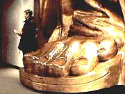 The team returned to Liberty Island in June to capture structural features such as the pedestal and feet that researchers could not record during the first visit.
 Three Dimensional
Texas Tech University opened a new realm of research possibilities with the acquisition of the Cyrax 3D laser scanner which makes documentation of monumental objects without the use of scaffolding safe and accurate. The Statue of Liberty project brought national and international attention to the project team and School of Architecture. |
Using upgraded equipment and benefiting from experience gained scanning for a range of preservation projects – including a field tent used by George Washington during the Revolutionary War and ancient dwellings in Mesa Verde National Park – Texas Tech researchers lead the growing pool of architecture programs entering the 3-D scanning field.
“The Statue of Liberty was our first official project using the scanner,” Louden said as her team prepared for its return to New York. “We were still learning, but we’ve got the process down now.”
To map the toughest-to-reach statue extremities, such as the top of her head, the team used the innovative approach of scanning Miss Liberty’s thin skin from the inside; since the skin is only about the width of a nickel, these measurements can be used to flesh out gaps left by measurements taken from the ground.
Team members also documented two auxiliary buildings related to Fort Wood, a star-shaped fort built around 75 years before the statue was constructed on top of it.