|
Bridging
the Texas Gap
|
|||||
| by Cade Nobles | |||||
 Texas
Tech University’s Texas Cooperative Fish and Wildlife Research Unit,
along with U.S Geological Survey and the Texas Parks and Wildlife Department
are working hand in hand to assess and keep data on the biodiversity of
Texas. Texas
Tech University’s Texas Cooperative Fish and Wildlife Research Unit,
along with U.S Geological Survey and the Texas Parks and Wildlife Department
are working hand in hand to assess and keep data on the biodiversity of
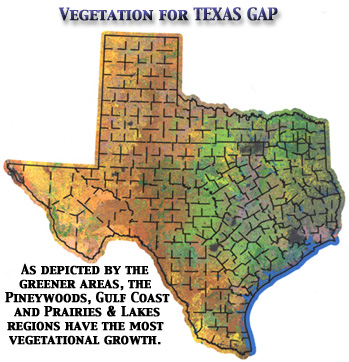
Texas.The Texas GAP Analysis is part of the National GAP Analysis Program established by the government. The Texas project is conducted by the Texas Cooperative Fish and Wildlife Research Unit at Tech. The purpose of the project is to assess and keep data on the biodiversity of Texas. This information is used to show distribution of animals and how the population growth of humans and animals affects the animals’ vegetation of Texas. It also gives data for professors and scientists to predict future problems and solutions. "We need to maintain some quality of life," said Nick Parker, unit leader and professor of the Texas Gap. Parker said that if you look, it is a rapidly eroding picture with more people and more pressure on the land and we (society) need to find a way to manage resources because growth fragments habitat. That is where the GAP Analysis project can help. Data collected can be used to help towns building new shopping centers or malls or even show which direction the growth of the town should go to minimize disturbance of plants and animals. The data can even help farmers and ranchers. The process of the project starts off with the state of Texas photographed by satellite imagery called a Landsat scene. This picture is 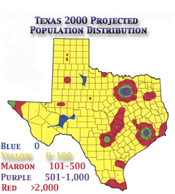 used to classify the vegetation. If the scientists want a close-up picture,
there is a higher imagery photo called the DOQQ (Digital Ortho Quarter Quad).
used to classify the vegetation. If the scientists want a close-up picture,
there is a higher imagery photo called the DOQQ (Digital Ortho Quarter Quad).After the satellite pictures are taken, a plane flies north to south and south to north transets at about 30-mile intervals throughout the entire state. Students working from the ground go to the area of these aerial transets and takes pictures north, south, east and west where highways cross the arial transets. So, now you have satellite imagery, plane imagery and imagery from the ground. These pictures give the data for the vegetation, soil and topography. These data are then placed with published information about birds, mammals, amphibians, that shows where these species live. Then data from the Census Bureau is taken into consideration because some cities have grown while others have lost population. After all of the data has been recovered, the answers show which cities have grown and where habitat has been severly altered. Native animals may be displaced or even killed in the cities’ expansions; where as other animals such as pigeons and English sparrows may flourish. "This information shows how elevation, soil, and type of land influences the disribution of people and also animals," said Parker. Parker said that was a significant difference around the Houston area. People are buying up the land outside Houston, and grading the surface to build houses, and fencing their property to keep livestock, primarly horses. This leaves no undergrowth or vegetation, the critical habitat for native species. This type of study is not just limited to vegetation and biodiversity of the animals, it also includes figures on temperature, precipitation and soil erosion. Small dust particles (particulite matter 2.5 microns), which humans breathe deeply into the lungs and are hard to get out of the lungs, pose a major health threat. The GAP project has already found ways to minimize PM2.5 particles in the atmosphere. The GAP Analysis project currently has 14 students, which may be graduate or undergraduates. They all do not come from the field of agriculture and have many different majors including biology, engineering, computer science and museum science. This diversity of students captures the strengths of many departments each bringing their special skills and knowledge to the project. In 1988, the federal government established the Texas Cooperative Fish and Wildlife Research Unit at Texas Tech University. Since then the Unit has worked with students and faculty throughout the University to address issues of importance to state and federal agencies. Additionally, these research projects have provided real life experience for both graduate and undergraduate students involved in research. The Texas GAP Analysis project has been a core component of that research. |
|||||