New Research on the 1970 Lubbock Tornado
MoTTU has been collaborating with the City of Lubbock Planning Department in engaging new research methods in looking back at the Lubbock Tornado of 1970. On the evening of May 11th two tornados touched down in Lubbock. The more severe second tornado started in the area of 19th & University about 935pm and made its way through the Overton and Guadalupe residential neighborhoods and the northern parts of downtown, before continuing north-northeast up the Amarillo Highway, through the County Club/Mesa Avenue area, and finally lifting after 30 minutes north of the airport. In its wake was over 15 square miles of utter devastation, several thousand residents displaced from their damaged or destroyed homes, and twenty-six people killed.
This spring the Museum was working towards mounting an exhibit this month, now delayed to Spring 2021 due to the COVID-19 pandemic. Stance Hurst, a faculty member who studies and implements use of 3-D technologies, has been working with history curator Cameron L. Saffell to apply today's technologies to 1970 aerial photography. The City of Lubbock Planning Department provided a series of more than 100 aerial photographs that were taken from an airplane two days after the tornado. The resulting photogrammetric model stitching these images together contains over 3 million digital data points.
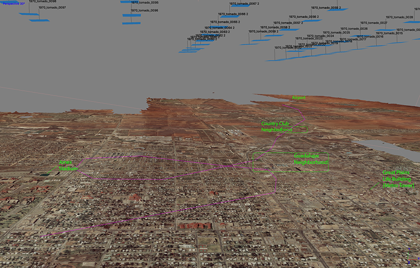
Click image for higher resolution.This image gives you a behind-the-scenes idea of how the photogrammetric process works and what it produces. In this side angle view, you can see the 3-D effects, including some of the damage from roofs torn off homes and other buildings destroyed (in the right-center area of this view). In the "sky" above you see blue boxes and labels that represent each aerial photograph in the model—which shows exactly where the plane flew over the city on each pass to create the overlapping aerial photographs. (The gray area at right is where a single aerial image is missing, leaving a "gap" in the model.)
This model allows us to switch the angles and views wherever we want. We will be able to create 3-D flyby and fly-through viewpoints of the aftermath of the storm from different angles and heights. Imagine being able to fly across the landscape on a flight plan that follows the tornado's path, seeing how wide and how extensive the destruction was. We also can generate several virtual reality views for the exhibit or the website. Our ultimate goal is to try producing a printed scale model of the City over which we can display major landmarks and the path of the two tornados. The Museum and the City Planning Department will continue to explore our new modeling and bring you new perspectives about the storm with historic newspapers, photographs, and artifacts from the 1970 Lubbock Tornado when we debut our next commemorative exhibit next year for the 51st anniversary.
Museum at Texas Tech University
-
Address
3301 4th Street, Lubbock, TX 79415 -
Phone
806.742.2490 -
Email
museum.texastech@ttu.edu

