
Water Management
Conservation and Management
 North Plains GCD
North Plains GCD Water Manager is an enterprise solution combining Esri, Geoserver and Openlayers. The desktop application will manage data entry for well permitting, registration, and production reporting. The web application will also integrate with the existing Geographic Information System (GIS) software and data managed by the NPGCD.
 High Plains Underground Water District (HPWD)
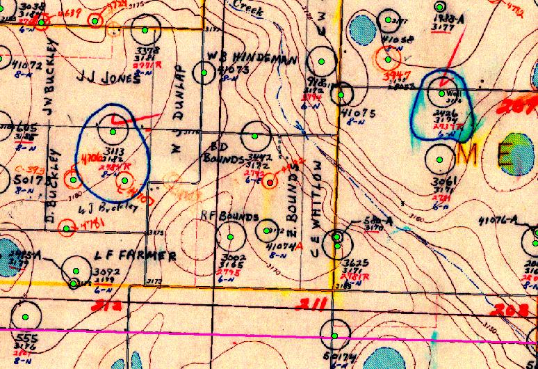
A geodatabase of irrigation wells and complimentary well permit management application were designed and developed for the High Plains Underground Water Conservation District, Lubbock, Tx. The GIS enabled the HPWD to build a framework to enable the District to make informed policy decisions for conserving water in the Ogallala Aquifer. The geodatabase contained over 72,000 irrigation wells over 15-counties in a region of about 10,700 square miles. Individual wells were digitized from 328 USGS topographic maps and attributes were compiled to build the well feature class. The geodatabase and well permit application was completed in under one year with five undergraduate students. The well permit management application enabled District staff to manage and maintain their well locations and well permit inventory.
 Texas Alliance of Water Conservation
Funded by the State of Texas, Senate Bill 1053 sponsored by Senator Robert Duncan, through the Texas Water Development Board, the goal of the Demonstration Project is to maximize producer profits while minimizing the use of water from the Ogallala Aquifer, and thus prolong agricultural productivity on the Southern High Plains.
 CRP Effects on Ogallala
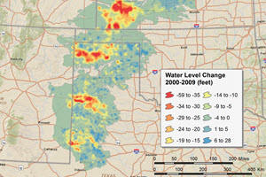
The Project Goal involved evaluating CRP as a service to minimize aquifer draw down. To meet this goal an analysis was developed to demonstrate if any differences in groundwater change occurred beneath Conservation Reserve Program (CRP) and non-CRP lands. And finally to quanitify any water savings on a regional and county level. To achieve these goals data for four time periods ranging from 1980 to 2008, were analyzed using a series of models. The results showed that land under CRP had the greatest benefit with respect to water level decline during dry periods, especially for counties with the greatest drawdown.