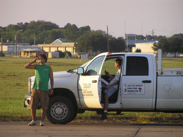
The Texas Tech University Hurricane Research Team is preparing for an active 26th hurricane season.

The StickNet "mass test" executed on June 3rd, 2024.
For over 25 years, Texas Tech University and the National Wind Institute (NWI) have pushed the envelope of hurricane research and observations. The Texas Tech University Hurricane Research Team (TTUHRT) was established in 1998 to develop a mobile and rugged meteorological platform to take valuable measurements within landfalling tropical cyclones. The two resulting Wind Engineering Mobile Instrument Tower Experiment (WEMITE) towers measured wind speed and direction at multiple levels, as well as barometric pressure, temperature and relative humidity. Three more Portable Mesonet Towers (PMT) were added to the fleet in 2002.
The five towers sampled a combined 23 landfalling tropical cyclones. Most notable deployments include (but are not limited to) hurricanes Georges (1998), Floyd (1999), Isabel (2003), Frances (2004), Ivan (2004), Katrina (2005), and Rita (2005).
 Current Senior Director of the National Wind Institute and Hurricane Research Team
founder, Dr. John Schroeder (right), and Research Professor, Dr. Brian Hirth (left),
deploying during Hurricane Rita (2005).
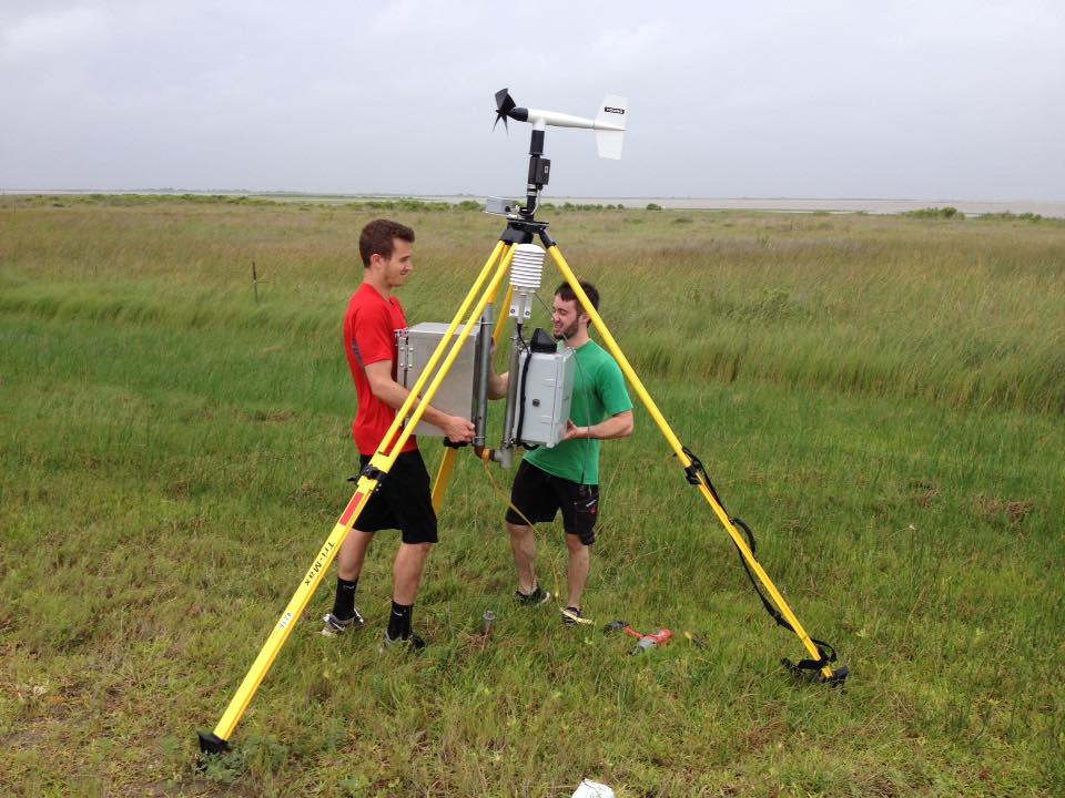
In 2005, Atmospheric Science and Wind Engineering graduate students were challenged to create a smaller, more mobile, agile, and rapidly deployable observing platform. The group designed, tested, and completed the first prototype of the StickNet platforms in 2006. At just over 7 feet tall, the platforms measured wind speed, direction, temperature, and relative humidity.
While the platforms were deployed on several severe thunderstorms since their creation, the fleet did not see its first hurricane action until 2008. From the fleet's debut in 2008 through 2017, 24 StickNet platforms were deployed in 11 landfalling cyclones. Some notable storms include (but are not limited to) Hurricanes Ike (2008), Sandy (2012), and Harvey (2017).
 Wind Science and Engineering PhD Student, James Duncan (left), and Atmospheric Science
Master's Student, Phil Ware, set up a StickNet prior to the landfall of Tropical Storm
Bill (2015).
In 2018, the fleet doubled to 48 platforms and added real-time communications to each, allowing the team to acquire more measurements from a wider portion of the coastline during landfalling storms. Since expanding to 48 platforms, TTUHRT has deployed on five different landfalling hurricanes, including Hurricane Florence (2018) and Laura (2020).
In 2006, NWI was awarded funding to develop two mobile, high-resolution radars. One of the radars was completed for the 2009 deployment of Tropical Storm Ida. The second radar was completed in 2010. Both radars have collected data during Hurricane Irene (2011), Laura (2020), and Delta (2020).

Since its inception, the TTUHRT has deployed platforms into 39 tropical cyclones.
Looking forward to TTUHRT's 26th hurricane season, the team is preparing to deploy all 48 StickNet platforms and the two Ka-band radars (if certain conditions are met). The team is executing its preseason “mass test” of the StickNet platforms. This test includes deploying all 48 platforms, collecting a week's worth of data, analyzing the data, and checking the platforms to ensure they are all in storm-ready condition if needed.
 The StickNet "mass test" executed on June 3rd, 2024.
Since the last TTUHRT deployment in 2021, the StickNet platforms have received several upgrades. The 24 platforms with temperature and relative humidity instruments received new and fleet-standardized instrumentation. The platform's batteries were upgraded to a more reliable battery system. The travel trailers' charging systems were also upgraded. And finally, a new F-350 truck replaced one of the older vehicles.
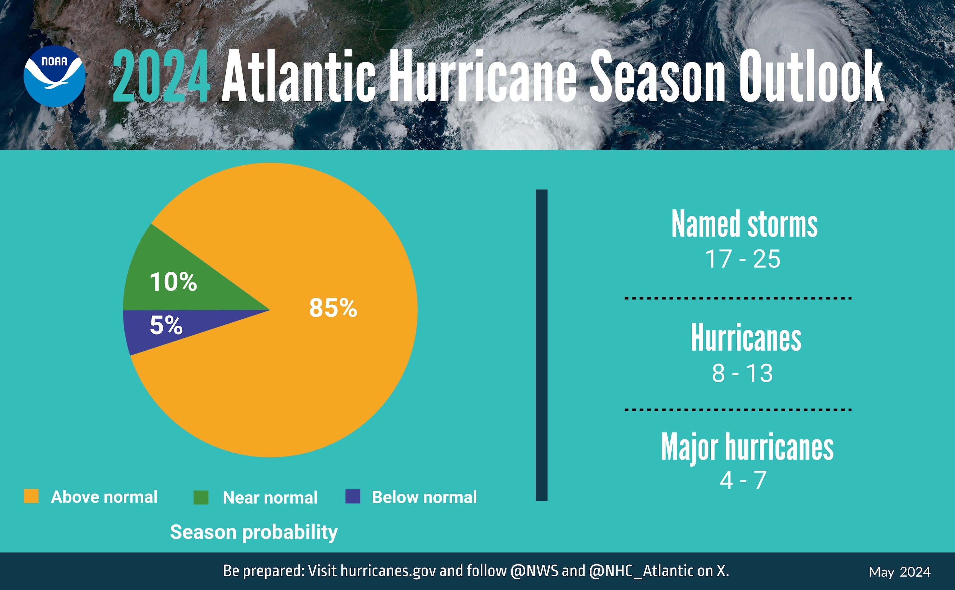
The NOAA forecasters at the Climate Prediction Center are predicting an “above-normal” amount of activity in the 2024 Atlantic Hurricane season. The center notably forecasted 17-25 named storms, with 4-7 including major hurricanes.

Infographic showing the probability of the 2024 season intensity compared to season averages and the number of storms predicted (Image credit: NOAA).
The predicted increase in activity is due to many factors: record-warm ocean temperatures, La Nina climate conditions reducing tropical wind shear, above-normal West African monsoons to produce the easterly atmospheric waves that create hurricanes, and light Atlantic trade winds that aid hurricane development and keep ocean waters warm (which fuels tropical cyclone development).
The forecast provided predicts overall hurricane activity (entire Atlantic Ocean and Caribbean Sea regions). It does not predict the number of landfalling hurricanes within the United States. The Climate Prediction Center will update this forecast later this summer.
2024 Hurricane season forecast and infographic courtesy of the National Oceanic and Atmospheric Administration (Link to NOAA Story).
