
Radars

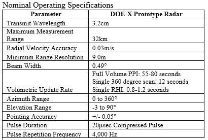
DOE X-band Radar
The DOE-X radar prototype was funded by the US Department of Energy and originally developed to advance wind plant complex flow measurements. The specialized radar has also been used for atmospheric and defense-related research agendas. Relative to other "off the shelf" radar technologies, the TTU specialized transmitter and receiver chains were specifically designed to enhance data availability in non-precipitating atmospheres. The new radar prototype was integrated at TTU using components from various suppliers across the world, and then was installed at the Reese Technology Center in May 2016.
Following installation, functionality and performance testing were completed, and subsequent comparative analysis indicated that the new prototype greatly enhanced data availability by a factor of 3.5-50 in almost all atmospheric conditions relative to the TTUKa radars (the baseline used for comparison).
The new prototype also provided enhanced signal quality in clear air (i.e. non-precipitating) environments, mitigated atmospheric attenuation, and extended the useful range of data collection to beyond 30km in cooperative atmospheric conditions.
Importantly, the new DOE-X prototype has shown some initial indications of benefiting from Bragg scattering when the thermal stratification of the atmosphere is strong (i.e. during nocturnal hours) providing a unique advantage for many applications. The radar prototype is also able to detect bird activity at ranges beyond 15km.
Commercial applications of the developed X-band radar concept have started with the deployment of two early-stage commercial units for DONG Energy in the United Kingdom by SmartWind Technologies (www.smartwindtech.com).
Starting in the summer of 2016, these units have been providing continuous dual-Doppler coverage of the Westermost Rough wind plant. The commercial effort has also resulted in additional software development to assist end users in evaluating, visualizing, querying and extracting relevant radar data from a large archive of measurement.
Ka-band Mobile Doppler Radar Trucks

One of NWI's two Ka-band radar trucks in the field collecting data.
NWI has two mobile Ka-band Mobile Doppler Radars. These fully coherent, pulse compression Doppler radar systems utilize traveling wave tube technology and provide the ability for four-dimensional mapping of a wide spectrum of atmospheric phenomena with very-fine spatial resolution useful for both the atmospheric science and engineering communities.
These data platforms allow our researchers to bring the radar instrumentation to the storm (instead of having to wait for the storm to arrive at their doorstep). They also enable four-dimensional mapping of atmospheric events which is useful for both atmospheric science and for wind engineering fields.
The radars are designed to enhance the sensitivity and the resolution of the data collected and allows more in-depth study of fine-scale atmospheric motions. They also have a higher resolution than that usually provided by other types of equipment which helps researchers "see" through the heaviest rains without losing much signal which means clearer (and more useful) data in the end.
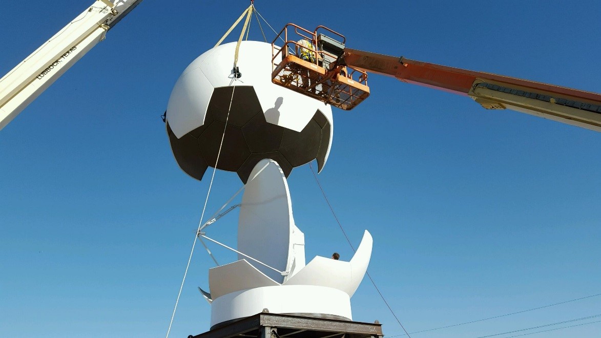
The white dome on the bed of each truck houses the radar and protects it from inclement weather - called a Ra-DOME and looks very similar to a large soccer ball.
Studying severe weather and tornadoes can be tricky as these weather events are often "small" enough to just fit between permanent weather observation stations which means that they can "slip through the net" data-wise. StickNets and Ka-band radar trucks are able to "zoom" in to the most important parts of the storm whilst staying a safe distance away from the dangerous weather.
By filling in the data "gaps", both the Ka-band radar trucks and the StickNet platforms provide a much more in-depth picture of the storm/weather event evolution over a period of time. This can lead to more accurate storm forecasts which may mean reduced wind damage and lower loss of life.
(Photo credit: Alex Schueth, Amtospheric Science Ph.D. Candidate.)
Radar Rates
Internal projects
(i.e. funded research projects through TTU)
Rollout Fee: $2000/radar/project
Transmitter Fee: $250/radar/hour
External Projects
(i.e. service center activity)
Rollout Fee: $3000/radar/project
Transmitter Fee: $375/radar/hour
TTU Ka-band Radar Specifications:
| Transmit Frequency | 34.86 / 35.06 GHz (for TTUKa-1 / TTUKa-2) |
| Transmit Power | 200 watts peak, 100 watts average |
| Transmitter Type: | TWTA, 50% duty cycle |
| Antenna Type | Cassegrain feed, epoxy dielectric |
| Antenna Gain | 56 dB |
| Antenna 3dB BW | 0.33 degrees |
| Polarization | Linear, horizontal |
| Waveguide | WR-28, pressurized |
| PRF | Variable, up to 20KHz |
| Pulse Width | 4 widths, variable from 30 nsec to 80 usec |
| Gate Spacing | 12 meters |
| Receiver | Dual block up/down converter |
| IF Frequency | 60 MHz |
| Pedestal System | Orbit AL-4016, 6 rpm max axis rotation |
| DSP | Sigmet RVP-900 with Tx IF modulator drive |
| Modulation | Pulse, Linear FM Chirp, Non-linear FM Chirp |
| Vehicle | Chevy C5500 crew cab, custom bed |
| Platform Stabilization | Computer assisted hydraulic leveling system |
Regional SODAR Network
SOnic Detection and Ranging (SODAR) are acoustic radars that are available to evaluate low-level atmospheric stability and wind characteristics.
The SODAR network is used for high resolution short-term wind forecasts and measures wind at different levels. (Wind speed tends to have different speeds at different heights from the ground which is useful for building safe structures and for use in academic and real-world projects.)
Six SCINTEC flat panel array units have been installed across West Texas and are part of the West Texas Mesonet (WTM) system. (See here for more information on the West Texas Mesonet system.)
SODAR units have been integrated with the WTM system to provide elevated measurements for high-resolution, short-term ensemble wind forecasts.
The SODARs run 10-minute scans at 10-m bin spacing. The first bin is at 30 meters above ground level (AGL) with wind speed and direction date available up to a maximum height of 380 meters AGL.

(Above) - Picture of SODAR unit in the field.
TTUKa-band Mobile Doppler Radars History
Radar Wake Research
National Wind Institute
-
Address
1009 Canton Ave., MS 3155 Lubbock, TX 79409-3155 -
Phone
National Wind Institute - 806.742.3476; Renewable Energy - 806.742.6284 -
Email
nwi@ttu.edu