
In the field
USGS EDMAP Grant -Dr. Katie Ardill
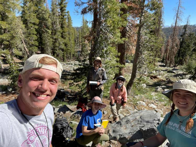
Igneous Petrology Summer Fieldwork Trip Report:
Over the summer, graduate students Lexi Bennett and Arnold Kotze, undergraduate students Jayden Flaming and Rocco Bowen, and Dr. Katie Ardill traveled to the Sierra Nevada mountains in California to generate a new 1:10,000 scale geologic map of the Iron Mountain pendant, a remnant slice of metamorphosed volcanic and sedimentary rock units that records information about magmatic and tectonic processes during Mesozoic arc activity. The project is funded by the USGS EDMAP program, supporting field-based research experiences and student training in geologic mapping and fieldwork activities. The primary outcome of this summer's field activities is a new geologic map across the central area of the Iron Mountain pendant which lies at the intersection of four 1:62,500 scale USGS quadrangles. Mapping will continue next summer to expand the map coverage and target new areas of interest.
For Rocco and Jayden, this was their first experience using a Brunton compass and locating themselves on a topographic map, skills they picked up in a matter of days. It was also a new experience in backcountry camping and cooking for all, discovering the versatility of chicken in a can. Primary graduate student mapper Lexi Bennett says: “With this opportunity, I was able to put together a combination of the skills I learned throughout my geoscience undergraduate studies and apply it to a real-world mapping research project. It amazed me how much I could accomplish with just a pen, paper, a Brunton compass, and a GPS miles away from civilization.”
Research continues over the academic year to interpret the geologic history of the area and what it can tell us about Sierra Nevada evolution through time. Students are preparing to perform whole-rock geochemical analyses as well as zircon geochronology in the spring.

Fluvana Paleontology Field Trip lead by Dr. Neo McAdams
by Theta Lubliner
Texas Tech University's undergraduate Paleontology and Paleoecology class, led by Dr Neo McAdams, ventured out to a roadcut near Fluvanna, Scurry County, Texas, which exposes Lower Cretaceous (Albian) strata assigned to the Walnut, Comanche Peak, and Edwards formations. The present-day picturesque prairie landscape was covered in a shallow marine environment diverse with ammonites, echinoids, gastropods, bivalves, and ornate rudist reefs. Students drew stratigraphic columns, took inventory of in situ specimens for diversity and sea level studies, and collected fossils to identify.
Texas Tech Geoscience students are fortunate to have paleontology-specific fieldwork to connect classroom learning to real field experience, collect data, and enrich understanding of sedimentary geology (e.g., depositional environments and sea level change) with paleontology and paleobiology. This opportunity was not available to undergraduates at my alma mater, although there are multiple undergraduate-level paleontology courses with research opportunities. Even as a PhD student, I see the importance of this field trip. The more outcrops, formations, specimens, and species examined make a better paleontologist and geologist.
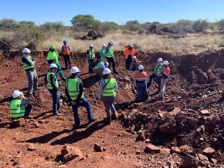
South Africa Field Experience lead by Dr. Callum Hetherington
by Tanner Crabbe
Professor Hetherington's study-abroad trip impacted me beyond my expectations, shaping both my ideas of a career path and perception of myself. My experiences while travelling throughout South Africa not only intensified my interest in geology and furthered my understanding of what the supply for a global economy looks like, but they also fostered my courage to venture the new and unknown.
Before applying to this program, I had no idea what the Bushveld Igneous Complex was, or what magnetite or chromite were. Given that I had only taken two geology classes, that's not unusual, but knowledge beyond the classroom just wasn't something I was looking for at the time. Honestly, my days consisted of much more leisure than work or school. Although I lacked the motivation, I wanted to know more about my major regardless. I was mildly interested in economic geology before, so when I got to hold two vital ores in my hands, it imbued me with fascination. I appreciated the sciences it took to understand their uses and characteristics, and that made my respect for the field grow. Additionally, visiting the mines and processing plants of the Transvaal and Bushveld gave me knowledge of the many steps it takes to go from exploration to reclamation. Our patron at the Lapon mine near Mokopane, Fabian, told us of the decade it took to discover the necessary reserve information it takes to green light a prospective mine. Not to mention the rehabilitation plan requirement and many other regulations that prevent the speedy completion of a project. Previously, I was under the influence that geologists in charge of locating economic materials would spend much less time than that on a single mine, so that realization made me think twice about my career plans. Deeper into the Bushveld, we saw the processing plants that produce most of the world's chromium supply. There were hundreds of trucks in lines miles long; each carried multiple tons of chromite and made several trips per day. The roads around the area bear the brunt of transporting millions of tons of the critical mineral, and they have been worn down to be more hole than road. Seeing physical representations of the industry's size helped me conceptualize the demand. Even after observing the daily workings of mines and plants, imagining how that material spreads across the world are still difficult, but now I have some notion of the enormous scale. All these examples, and others, instilled a sense of importance of geology in my life, which may not have happened had I not took the chance to attend.
From the start of my involvement in the trip, I was making decisions out of my comfort zone. I was introduced to the opportunity just a day before applications were due, and although something felt right about signing up, it was still nerve-racking. After our arrival in Pretoria, we visited a township named Mamelodi, where I experienced something like nothing else I've done in my life. We were to drive around the township and interview its residents. Mamelodi, created by apartheid, is a massive, rapidly expanding suburb of Pretoria, so our interviewees had been subjected to challenges I couldn't imagine going through myself. Comparing my life with theirs quickly made me feel grateful for everything I had. Later on that day, Thato, our driver, took us to his neighborhood. We kept going deeper and deeper into the township and stopped on a dead-end road. There were his friends and family who gathered to see us and welcomed us warmly, but I was still on-guard due to my preconceived notions of what could happen in a situation like that. But, once I took the time to talk with our hosts, I realized how kind they all were and what I would've missed if I refused to leave the van. These are just two out of many escapades provided by this trip, all of which came together to make me much more willing to take on new things. Coming back from South Africa, I've become more involved in the geology department by regularly attending visiting speaker's seminars and getting a job as a student assistant! My growing interest in geology really makes it exciting to continue learning about the subject, and I'm extremely thankful I seized this opportunity.
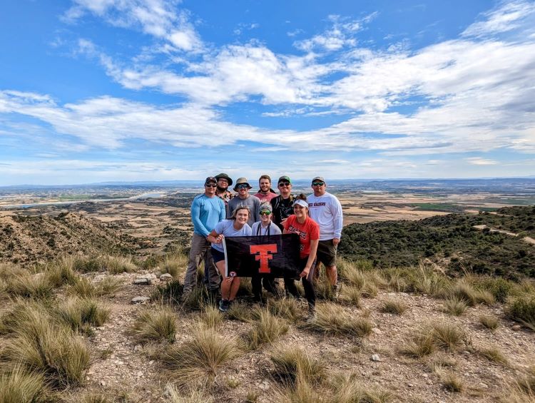
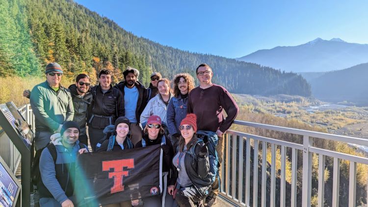
Ebro Basin, Spain and Olympic National Park, Washington leab by Dr. Jeff Nittrouer
by Stacy Gifford
Over the last year, I have been fortunate enough to partake in exceptional field experiences with the geosciences department at Texas Tech University. In May of 2023, I spent a week in central Spain examining a Paleocene-aged basin and looked at the modern Elwha and Nisqually rivers in Washington state in October. Both field excursions were collaborative projects with Texas tech students working with colleagues and students from external universities. The Spain trip included Wyoming State University and West Texas A&M University. The Washington trip featured the University of Washington's geomorphology group.
Historically, the Ebro basin was an endorheic basin with no outlet to the sea. All three sides of this triangular basin are surrounded by mountain ranges, meaning all precipitation and sediment transport was trapped within its confines. This has led to a unique environment that has preserved millions of years of river systems within the rock record. The Ebro basin has Earth's longest preserved channel complexes; some are contiguous for over 100km long! Without trying to oversell it, nowhere else on Earth offers this complete level of preservation and exposure in outcrop. These outcrops are world-class, and channel fills, many even stacked upon one another, are preserved in cross sections in the outcrops (sometimes seen in road cuts). It was exciting to hear everyone's interpretations of differences seen across deposits in different parts of the basin system, representing different changes in the history of the river-to-basin system. The views of the Spanish countryside are hard to beat, too.
While in Spain, we stayed in a beautiful old Spanish-style farmhouse located more or less in the middle of our study area. Our first day had an admittedly strenuous hike in the Catalonia Mountain range. Once at the top of our 6.52-mile hike, we were rewarded with a spectacular view north overlooking the Ebro basin. While maps and reading are undoubtedly integral to understanding a study area, seeing the entirety of the basin provides a far more human scale. Throughout our week of field experience, we started at the source of the rivers, high in the Pyrenees mountains on the northern edge of the basin. Following them down to their eventual terminus in the central and southern portions of the basin at the end of the trip. As we progressed downstream, the channel deposit geometries, slope, and grain characteristics gradually changed to match.
The Elwha River, located on the Olympic Peninsula in Washington state, is notable for a historic ecological restoration project. The Elwha River flows through the Olympic National Park, originating in the Olympic Mountains and draining into the Strait of Juan de Fuca. One of the most significant environmental initiatives in the region was the removal of two large hydroelectric dams, the Elwha Dam, and the Glines Canyon Dam, in a project that began in 2011. The removal of these dams aimed to restore natural sediment transport, improve water quality, and revive fish populations, particularly salmon. The removal of the dams allowed the Elwha River to return to a more natural state, promoting the recovery of its ecosystem. The river and its dam removal are also of geologic and morphodynamic significance as they provide real-world examples of morphodynamic feedback and response to sudden changes in water flow. The dams and their subsequent removal provide insights into sediment catchment, transport, and recovery.
The format of this fieldwork was much the same as that in Spain; we started at the river source, the Nisqually Glasure, on the slopes of Mt. Rainier. Then, following it 81 miles to its delta in Puget Sound. The following days we were able to examen tsunami deposits, an estuine system and evidence for significant beach erosion due to longshore sediment transport. Our final day had us stop at the Elwha Reservoir overlook and onward to Madison Falls Trailhead, where we will have the opportunity to hike to Glines Canyon Dam Spillway Overlook to observe the largest dam removal project in the United States.
Participating in fieldwork has been an incredibly enriching experience as a geologist. Being out in the field provides a unique opportunity to witness geological processes and formations directly, beyond what textbooks and classrooms offer. The hands-on nature of fieldwork has significantly honed my observational, analytical, and problem-solving skills — all essential for a successful career in geology. There is a distinct advantage to interpreting geological features in their natural context, understanding local variations in rock types, and observing the dynamic forces at play in shaping the Earth's surface. These experiences are crucial for bridging the gap between theoretical knowledge and practical application. Fieldwork has not only deepened my understanding of geological systems but has also cultivated adaptability as each location presents its own set of challenges and unique geological features. This synthesis of on-site observations and academic knowledge is enhancing my proficiency as a geologist, preparing me for the diverse and dynamic challenges in the field.
Department of Geosciences
-
Address
Department of Geosciences, 1200 Memorial Circle, Lubbock, TX 79409-1053 -
Phone
806.742.3102 -
Email
geosciences@ttu.edu