
WTM 5Hz Research
In recent years, the West Texas Mesonet has been upgrading their stations to record a select number of variables at 5-Hz (i.e., 5 measurements per second). Variables that are collected at 5-Hz include the barometric pressure, 10m wind speed and direction, 1.5m temperature, humidity, and dewpoint. Previously, stations sampled these parameters internally every 3-sec, but only reported averaged measurements every 1-min for the data archive. By providing 5-Hz “research” output, our stations can now record transient events and features that would be otherwise be lost (i.e., averaged out) from the records.
A recent example occurred during the evening of February 26, 2023, when a storm system passed by the mesonet station located at Memphis, TX as shown in Figure 1. During that event, the station recorded a wind speed of around 51m/s, or 114mph, along with a substantial drop in pressure (Figure 2). The measurements from each 5Hz variable are shown in Figure 2, along with what each variable would have looked like using a 1-min averaging period. Without the 5Hz research data, an extraordinary amount of detail would be lost.
Another event occurred on April 26, 2023, when a tornadic supercell passed over the location of the McAdoo Mesonet station. Radar data (Figure 3) indicate the rotation passed just north and east of the station, while the station's 5Hz output documented another transient high wind event, along with a supporting pressure drop (Figure 4). It appears the high winds were associated with the rear flank downdraft (RFD) of the passing supercell based on the location of the circulation in relation to the station and the measured wind directions by the station (Figure 4). In fact, there were two wind peaks embedded in the event and both were associated with drops in pressure.
The 5-Hz research data allows one to gain additional understanding that would otherwise would be lost, and it significantly enhances our ability to document what happened in these transient events. This new capability serves our research community, as we try to better understand these quick hitting events. In the future, we are contemplating making instrumentation upgrades that would further bolster this capability.
 Figure 1: KLBB radar images of reflectivity (top) and radial velocity (bottom) near
the time of max wind gust at the Memphis mesonet station.
Figure 1: KLBB radar images of reflectivity (top) and radial velocity (bottom) near
the time of max wind gust at the Memphis mesonet station.
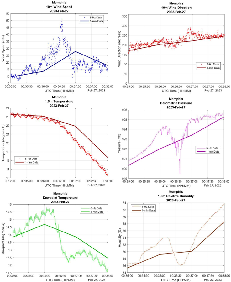 Figure 2: 3-min period for all 5-Hz variables during which the max wind gust occured
with what what the 1-min data would have looked like overlaid. From left to right
and top to bottom we have 10m wind speed, 10m wind direction, 1.5m temperature, barometric
pressure, 1.5m dewpoint, and 1.5m relative humidity.
Figure 2: 3-min period for all 5-Hz variables during which the max wind gust occured
with what what the 1-min data would have looked like overlaid. From left to right
and top to bottom we have 10m wind speed, 10m wind direction, 1.5m temperature, barometric
pressure, 1.5m dewpoint, and 1.5m relative humidity.

Figure 3: KLBB radar image of radial velocity showing the McAdoo Mesonet within the
vicinity of the RFD of the passing supercell.

 Figure 4: 20-min of 5-Hz wind speed and barometric pressure (left) and wind direction
(right) data taken from the McAdoo Mesonet as the supercell passed over the station.
Figure 4: 20-min of 5-Hz wind speed and barometric pressure (left) and wind direction
(right) data taken from the McAdoo Mesonet as the supercell passed over the station.
National Wind Institute
-
Address
1009 Canton Ave., MS 3155 Lubbock, TX 79409-3155 -
Phone
National Wind Institute - 806.742.3476; Renewable Energy - 806.742.6284 -
Email
National Wind Institute - nwi@ttu.edu; Renewable Energy - windenergy@ttu.edu