
Science Reports
Clay Mineralogy in Geological Studies
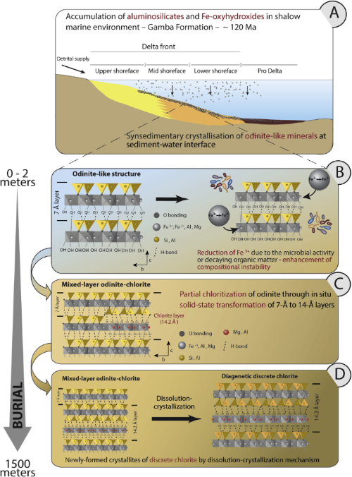
by Branimir Segvic, Assistant Professor (Mineralogy)
Clay minerals are encountered in a variety of geological materials and, as such, represent
an important line of research. Due to the environment in which they appear, that is
constantly crisscrossed by man's activity, clays are studied from different aspects
of human endeavor (e.g. oil and petroleum research, environmental studies, radioactive
waste storage). Clay minerals are normally present whenever water and rock meet. They
are common products of weathering, and may hold a key role in the diagenetic evolution
which takes place in sedimentary basins during sediment burial.
The TTU clay mineralogy group is one of the few in the country specialized in the
study of these complex layered aluminosilicate. Our graduate and undergraduate students
investigate clay minerals from a range of geological environments starting with deep
sedimentary basins through weathering and soil profiles. We study mineral structures,
crystal chemistry and transformation/reaction mechanisms which lead to the formation
of characteristic clay phases. These are critical to fully constrain the prevailing
environmental conditions in order to add to our understanding of geological history
of investigated area(s). Our research is highly collaborative and interdisciplinary
as we work with the colleagues and students from across TTU campus (Petroleum Eng.,
Civil Eng., Plant and Soil Science) and beyond (nationally and internationally). We
collaborate extensively with petroleum industry assisting with material characterization
and reconstruction of diagenetic models. Our work is based on quantitative and qualitative
analysis of sedimentary/low grade metamorphic rocks and soils done by X-ray diffraction
and scanning electron microscopy. We also routinely use a range of other spectroscopic
techniques. To learn more about current projects in our group please visit https://www.clay-group-segvic.com/.
Mapping global land change using satellite data
By: Dr. Song
Humanity depends on land for food, energy, living space and development. Land-use change—traditionally a local-scale human practice—is increasingly affecting Earth system processes, including the surface energy balance, the carbon cycle, the water cycle and species diversity. As population and per capita consumption continue to grow, so does the demand for food, natural resources and consequent stress to ecosystems. Because of their synoptic view and recurrent monitoring of the Earth's surface, satellite observations contribute substantially to our current understanding of the global extent and change of land cover and land use. Most recently, Xiaopeng Song, in collaboration with colleagues at the University of Maryland and NASA Goddard Space Flight Center, analyzed 35 years' worth of coarse-resolution (5km) satellite data, found that the world's land surface has experienced a net gain in tree cover from 1982 to 2016 with substantial regional variations. The United States Geological Survey opened the Landsat archive in year 2008, which provides satellite imagery at sub-100m resolution dating back to 1972 – a consistent and freely available data record over the past half century. The European Space Agency also adopted an open data policy, providing sub-weekly satellite data at 10-20m resolution since 2015. Other sources of spaceborne and airborne remote sensing datasets (e.g. light detection and ranging or Lidar) are increasingly available, offering a range of exciting data streams for land change research. However, turning remote sensing data into interpretable information requires advanced computer infrastructure, domain geographical knowledge, engineering skills, and often times field surveys. The Remote Sensing team at Texas Tech is developing students to become next generation remote sensing scientists who are capable of mining satellite data archives with High-Performance Computing clusters for land change characterization. These skills are also useful in industry applications such as land-use planning, agriculture, forestry and rangeland management.
Mapping lightning from the ground … and space!
By: Eric Bruning
We are all familiar with the spectacular lightning strikes to ground that accompany thunderstorms, but there are 5-10 times more lightning flashes inside the cloud! The West Texas Lightning Mapping Array (WTLMA), a network of radio receivers in and near Lubbock county, allows us to map out 100s or 1000s of points along the lightning channels for every flash in the storm. For most flashes, the lightning channels extend about 5-10 mi horizontally. The largest reach in excess of 100 miles, and near the updraft of storms there are many that are less than a mile wide.
The lightning research group at Texas Tech University found evidence that the smallest lightning flashes are found near the storm's updraft. The updraft is a region of fast upward motion in storms that is also very turbulent. The turbulence causes many small flashes because the gusty motions chop up the distribution of electricity in the cloud. More, small flashes happen when the updraft increases. In contrast, the regions with the largest flashes are found in regions of relatively smooth, primarily horizontal motions. To better understand the physics behind these observations we have been comparing flash rate and size information to turbulence measurements using the TTU Ka-band mobile Doppler radars. Our basic research, funded by a 5-year award from the National Science Foundation, has helped establish this sound understanding of the basic science relating lightning to the rest of thunderstorm meteorology.
One of the byproducts of our basic science studies was a set of data displays that helped to visualize where large and small flashes happened in thunderstorms. In the last year, we applied our physical insights and method of summarizing flash rate and size data on maps to brand new measurements by the Geostationary Lightning Mapper on NOAA's next-generation weather satellite system. The WTLMA served as a validation dataset that verified the performance of the satellite system. Furthermore, we rapidly translated our fundamental research into displays and training material that filled a gap for the US National Weather Service. Weather forecast offices nationwide, including the Lubbock office, are using these products designed right here at Texas Tech.
The public is served through better monitoring of thunderstorms as a result. Changes to a storm's updraft drives the weather produced by a storm, including severe weather, so severe storm warnings benefit from lightning data that update each minute and depict fluctuations to the updraft. As larger lightning flashes develop later in a storm's life, depicting their extent helps to map out the total area under threat from lightning strikes and enhanced public safety.
Department of Geosciences
-
Address
Department of Geosciences, 1200 Memorial Circle, Lubbock, TX 79409-1053 -
Phone
806.742.3102 -
Email
geosciences@ttu.edu